Canstar and VMS Mining Secure Key Permits, Advance Structural Mapping and Core Logging at Mary March VMS Project, Laying Foundation for Future Drill Program
Toronto, Ontario – [Newsfile Corp. – August 7, 2025] – Canstar Resources Inc. (TSXV: ROX, OTC: CSRNF) (“Canstar” or the “Company’) reports that a rigorous historical core mapping program led by Dr. Harold Gibson and Dr. Rodney Allen has been initiated at Canstar’s Mary March Project, located in central Newfoundland, 20 kilometres east of the former producing Buchans Mine.
Under the $11.5M joint venture with VMS Mining Corporation (“VMSC”), this core mapping will form the backbone of a systematic “geology forward” strategy to define the stratigraphic and structural controls on the volcanogenic massive sulfide (“VMS”) mineralization and alteration intersected at Mary March and Nancy April to target faulted extensions and to define new, high-quality VMS targets.
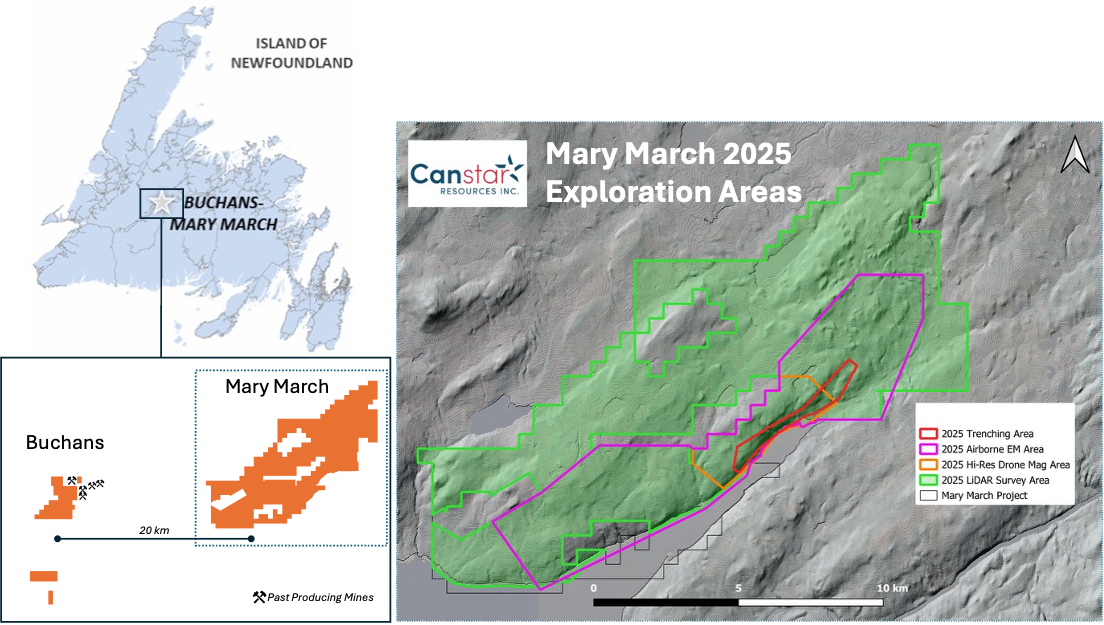
The initial focus will be on the core from two mineralized intervals and will extend outwards from these. Trenching and geological mapping at Mary March–Nancy April, aided by a new Light Detection and Ranging (“LiDAR”) survey, will overlap and continue after the core mapping and relogging program.
Highlights
- Geological reinterpretation to identify new, high-quality drill targets using a “geology forward” approach
- Detailed graphic core mapping campaign aims to unravel stratigraphic and structural controls on known mineralization that will be coupled with LiDAR-aided mapping to develop new targets
- Deep Induced Polarization (“IP”) survey at Buchans completed; advanced 3D modelling underway to assess large, multi-kilometre-scale airborne electromagnetic (“EM”) conductors and other areas of conductor anomalism at Canstar’s Buchans Project
- New LiDAR survey flown on Mary March to support geological mapping and structural studies, with data interpretation expected soon
- Exploration permits received for trenching, geophysics, and geochemistry
“Our strategy is clear: build a coherent geological model, identify the structural and stratigraphic setting for the known faulted high-grade VMS lenses, target faulted extensions of the known mineralization, define new targets and then drill smart,” said Juan Carlos Giron Jr., President & CEO of Canstar. “We’re doing the work the right way—deep science, deliberate execution, and world-class expertise focused on discovery.”
Geology-Led Approach Driving Target Definition
Canstar and VMSC’s exploration team is employing a methodical, geology-first approach to exploration in the historically productive yet structurally complex Buchans VMS district. Dr. Harold Gibson and Dr. Rodney Allen—two of the most experienced VMS experts worldwide—recently spent 10 days on site, conducting detailed graphic relogging of historic core from the Mary March and Nancy April prospects, situated approximately 20 kilometres east of the historic Buchans mining camp, where Canstar also has a significant VMS project, which is also part of the Joint Venture. The Buchans deposits are among the world’s highest-grade polymetallic (Zn-Pb-Cu-Au-Ag) VMS deposits, with a Zn equivalent grade of 48% (produced 16.2 Mt @ 14.51% Zn, 7.56% Pb, 1.33% Cu, 126 gpt Ag, and 1.37 gpt Au from 1928 to 1984).1
Their work confirms that the lithofacies at Mary March and Nancy April are similar to those at the Buchans deposits, including the presence of sericite and chlorite altered lava domes, with stockwork-style stringer zones.
Crucially, their analysis supports the interpretation that the known high-grade and gold-rich Mary March massive sulfide—although bounded by thrust faults—is preserved within its original stratigraphic position atop an altered rhyolitic dome. The stringer mineralization at Nancy April occurs within a coherent, sericite and chlorite altered rhyolitic dome, but is faulted and offset from its massive sulfide lens. The rhyolitic footwalls at Mary March and Nancy April are geochemically distinct from each other and represent separate lava domes.
“The Mary March–Nancy April area is emerging as a classic VMS system—rhyolite-hosted, hydrothermally altered, fault-modified, and underexplored,” said Dr. Allen. “Reconstructing the volcanic stratigraphy is essential to tracing the ‘ore horizon’ and understanding where the remaining sulphide bodies may be found.”
Permits Secured at Mary March, Field Work Accelerating
The Company has received multi-year exploration permits enabling a range of activities, including:
- Ground geophysics (deep IP, borehole EM)
- LiDAR and drone-based terrain analysis
- Mechanical trenching, backpack drilling, and geochemical sampling
A new deep-penetrating IP survey—initiated in early 2025 in partnership with Canterra Minerals—has been completed. Modelling is underway to evaluate the 3D chargeability response, with particular focus on historic airborne EM anomalies within Canstar’s Buchans claims. These anomalies occur in proximity to interpreted Buchans River Formation stratigraphy, which hosts all five historic high-grade Buchans deposits.
In parallel, a high-resolution LiDAR survey was flown to assist in structural interpretation, terrain correction for geophysics, and logistical planning for upcoming trenching and drilling.
Looking Ahead: Drill-Focused, Science-First
With foundational work accelerating, the joint venture remains focused on unlocking new high-grade discovery potential across the district. Near-term efforts are centred on:
- Finalizing the revised stratigraphic and structural model based on core logging, geochemistry, and geophysics
- Identifying and prioritizing new drill targets with enhanced geological context
- Preparing for a trenching campaign at Mary March–Nancy April in the third quarter
About the Joint Venture
Canstar and VMSC announced the foundation of an $11.5M strategic exploration partnership in 2025 to explore and advance high-grade VMS prospects across the Buchans and Mary March district. The partnership leverages the technical and capital strengths of both companies, with Canstar serving as operator during the initial exploration phases. Following the execution of the LOI for the JV in April 2025 and receipt of the initial payment for the Phase 1 exploration program in May 2025, Canstar and VMSC are continuing to finalize the definitive agreements for the partnership, with expected completion in Q3 2025 in parallel with ongoing joint exploration activities.
Qualified Person
Bob Patey, B.Sc. (Hons), VP Exploration for Canstar and a Qualified Person as defined in NI 43-101, has reviewed and approved the scientific and technical information in this news release.
Acknowledgement
Canstar acknowledges the financial support of the Junior Exploration Assistance (JEA) Program from the Government of Newfoundland and Labrador Department of Industry, Energy and Technology, which has been a valuable contribution to the exploration programs on the Company’s Buchans-Mary March and Golden Baie projects.
About Canstar Resources Inc.
Canstar Resources Inc. (TSXV: ROX) is an exploration company focused on critical minerals and gold. The Company’s 100%-owned Golden Baie Project (489.5 km2) hosts high-grade gold and antimony showings along a major mineralized structure that also hosts a large number of gold deposits. The Buchans and Mary March projects (122.5 km2) are located within the world-class, past-producing VMS zinc-, copper-, and silver-rich Buchans Mining Camp and boast high-grade zinc and copper discoveries.
For further information, please contact:
Juan Carlos Giron, Jr.
President & Chief Executive Officer
Email: [email protected]
Phone: (647) 557-3442
Website: www.canstarresources.com
Citations
- Wardle, R.J., 2008: Zinc and Lead. Government of Newfoundland and Labrador, Department of Mines and Energy, Geological Survey, Mineral Commodities Series 1, 11 pages
Neither TSX Venture Exchange nor its Regulation Services Provider (as that term is defined in the policies of the TSX Venture Exchange) accepts responsibility for the adequacy or accuracy of this release.
Forward-Looking Statements
This news release contains “forward-looking statements” that are not historical facts. Forward-looking statements relate to future events or performance and include, but are not limited to: the objectives, scope, and anticipated benefits of the $11.5 million joint venture with VMSC; expectations that geological mapping, relogging, LiDAR surveys, and geophysical modelling will identify and refine VMS drill targets; planned trenching, drilling, and other exploration activities; interpretations of geological similarities to the historic Buchans deposits; and the expected completion of a revised geological model and definitive joint venture agreements in Q3 2025.
Such statements are based on current assumptions and subject to known and unknown risks and uncertainties that may cause actual results to differ materially, including: failure to complete the definitive JV agreement; geological interpretations proving inaccurate; exploration activities not yielding expected results; delays or inability to commence planned programs; permitting or logistical challenges; and general exploration, market, and commodity price risks. Additional risks are described in the Company’s public filings on SEDAR+.
The Company does not guarantee that forward-looking statements will prove accurate, and actual results may differ materially. Forward-looking information is provided as of the date of this news release, and the Company undertakes no obligation to update or revise it except as required by law.